E.1. Land uptake
Brief description:
land uptake by land type (land use) including land under roads and other transport infrastructure, public use land, land under construction, damaged land, unused land, other land;
percentage of land uptake in the total area of the country.
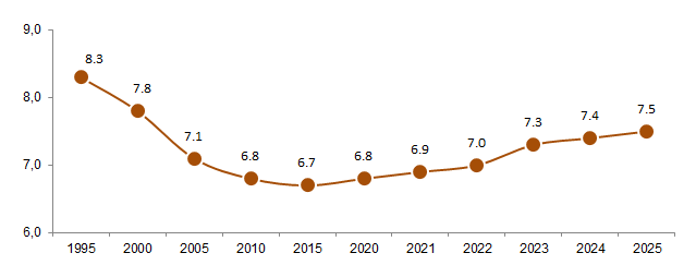
Proportion of land uptake
in the Republic of Belarus
(as percentage of total area of the country)
Methodology:
The indicator is formed in accordance with the Guidelines for the application of environmental indicators in Eastern Europe, Caucasus, Central Asia and South-Eastern Europe (Guidelines for the Application of Environmental Indicators | UNECE).
The indicator E1 “Land uptake” includes such land types as land under roads and other transport infrastructure, public use land, land under construction, damaged land, unused land, other land in accordance with the national terminology.
Land under roads and other transport infrastructure is land sealed by roads, glades, linear structures.
Public use land is land occupied by streets, avenues, squares, passages, embankments, boulevards, public gardens, parks and other public places.
Land under construction is land occupied by the permanent buildings as well as land adjacent to these objects and which is used for its maintenance.
Damaged land is land which lost its natural and historic characteristics, state and pattern of use in the result of harmful anthropogenic impact and which is in the state excluding its effective use by its primary purpose.
Unused land is land which is not used in economic or other activity.
Other land is land which is not defined as agricultural land, forest land, land under wood and bushes, land under swamps land under surface water bodies, as well as land under roads and other transport infrastructure, public use land, land under construction, damaged land, unused land.
Data source:
Departmental reporting report 22-зем "Отчет о наличии и распределении земель" (Report on the availability and distribution of land); the data producer is the State Committee on Property of the Republic of Belarus.
Relevance of the indicator:
The indicator defines impact of human activity on environment by urban and transport networks development, resource use, waste storage.